Renowned as one of the Seven Natural Wonders of the World with extraordinary universal values, Ha Long Bay was first recognized by UNESCO as a World Natural Heritage site in 1994, based solely on its outstanding aesthetic appeal. The breathtaking beauty and aesthetic value of the Bay’s natural landscape are mirrored in the graceful contours and rich hues of its limestone islets. However, it is the sophisticated geological and geomorphological structure of the bay that breathes life into such mesmerizing scenery. Consequently, the remarkable geological and geomorphological values of Ha Long Bay deserve meticulous preservation for the benefit of generations to come. This article provides discerning travelers with a deeper insight into these invaluable heritage treasures.
You might also be interested in:
The Geological Formation Process of Ha Long Bay
The coastal areas and surrounding zones of the Bay are composed of dense layers of limestone and fragmental sediments dating from ancient epochs to the modern era. This serves as a magnificent canvas illustrating geological processes spanning hundreds of millions of years. Throughout this vast expanse of time, while the coloration, composition, and architecture of the limestone strata were being shaped, fossilized remains were carefully preserved within the layers. These elements, combined with the intrinsic nature of the sediments, contribute to a comprehensive scientific record of the region.
Many sedimentary rocks contain remnants and traces of ancient flora and fauna in various forms, including species that vanished millions of years ago. This leaves behind a rich repository of information regarding the evolution and development of life on Earth.
Regarding its geological structure, Ha Long Bay lies within the Coastal Zone of the Caledonian-Cathysian tectonic framework, having been influenced by volcanic activity at the dawn of the Paleozoic era. Upon the Caledonide folded basement, the Indosinian tectonic movement in the late Triassic era led to block faulting and the deposition of coal-bearing strata (anthracite). Vietnam’s renowned deep latitudinal fault system developed within this region. This sequence of tectonic shifts also forged the Cửa Lục and Ha Long depressions, which were subsequently submerged. Relics of both ancient and recent tectonic dynamics are vividly manifested in the Ha Long Bay region through the intense deformation of sedimentary layers, such as gentle and overturned folds, normal and reverse faults, and tectonic breccia belts. These stand as nature’s living sculptures preserved across majestic limestone cliffs.
Ha Long Bay boasts an ancient geological history shaped by diverse paleogeographic environments beginning nearly 570 million years ago. Between the Ordovician and Silurian periods (500 to 410 million years ago), the region was a deep sea. Subsequently, during the Carboniferous and Permian periods (340 to 250 million years ago), the area transitioned into a shallow marine environment. By the late Paleogene and early Neogene epochs, spanning 26 to 20 million years ago, these waters evolved into part of an expansive coastal plain. The region underwent repeated marine transgressions throughout the Quaternary period over the past 2 million years. Present-day Ha Long Bay was sculpted approximately 7,000 to 8,000 years ago due to marine encroachment during the Holocene sedimentary evolution, which commenced roughly 17,000 to 18,000 years ago.
The geological history of Ha Long Bay encompasses three major orogenic cycles. The first was the formation of the Caledonide geosynclinal fold belt in the late Silurian period, approximately 410 million years ago. The second was the consolidation of the Indosinian platform in the late Triassic period, roughly 200 million years ago. The final Alpine orogeny in the late Paleogene epoch, around 30 million years ago, created the differentiation between horst blocks and graben depressions, laying the structural foundation for the future Ha Long Bay. Two prominent paleogeographic environments existed in the Ha Long Bay area. The Carboniferous period, spanning 340 to 285 million years ago, was globally warm, during which colossal swamps formed vast coal basins in Europe and America. In Ha Long Bay, carbonate sediments accumulated in shallow seas under arid and hot conditions, gradually forming thick limestone strata. Over hundreds of millions of years, the ocean floor steadily subsided, allowing shallow-water limestone to accumulate into thick layers ultimately reaching 1,200 meters in depth, thereby creating the ideal conditions for the characteristic karst landscape. Conversely, during the Triassic period between 240 and 195 million years ago—when much of the globe experienced arid and hot climates—the Ha Long region enjoyed a hot and humid environment. The decayed remnants of giant fern forests became the foundation for the region’s rich coal deposits.
2. Geological and Quaternary Values
The Ha Long Bay region preserves numerous precious characteristics of the Quaternary period. Quaternary sedimentary layers and the flat seabed topography help preserve ancient riverbeds, cave systems, and sediment accumulations. Vestiges of ancient marine activity forming characteristic notches serve as vital evidence of geological events and processes that transpired during the epoch of human existence on Earth. Particularly from the Holocene epoch—some 11,000 years ago when modern, intelligent humans evolved—Ha Long Bay holds abundant archaeological evidence connecting fluctuating sea levels with the development of ancient cultures such as the Soi Nhụ and Ha Long cultures. Regrettably, this aspect has yet to be thoroughly researched or evaluated in detail. In terms of marine geology, Ha Long is recognized as a modern sedimentary basin, a bay created by a barrier island system. The bay experiences strong tidal currents yet gentle wave action. Within an alkaline environment, the chemical dissolution of calcium carbonate occurs rapidly, giving rise to expansive and uniquely shaped sea notches. This appears to be an active process associated with the supply of CO2 generated from the respiration of algae and aquatic plants thriving in Ha Long Bay.
3. Karst Geomorphological Values
Within Ha Long Bay, the primary accessible caves are ancient conduits that survived from the active periods of karst development, despite spanning various phases of fengcong and fenglin evolution. Three main categories of caves can be identified among the limestone islands:
1- Relics of ancient subterranean river caves
2- Ancient karst base-level foot caves
3- Notch caves (sea caves)
The first group—relics of ancient subterranean river caves—includes Sung Sot (Surprise), Tam Cung, Lầu Đại, Thien Cung, Dau Go, Hoàng Long, and Thiên Long caves. Today, these caverns lie at varying elevations. Sung Sot Cave is situated on Bồ Hòn Island. From truncated entrance chambers high on the cliffside, a lofty and spacious passageway over 10 meters wide slopes downward to the south. Tam Cung is a cavern featuring large fracture planes developed along the limestone bedding, dividing the fractured cave into three chambers. Thien Cung and Dau Go are remnants of the same ancient cave system. Both lie on the northern side of Đầu Bỗ Island at elevations between 20 and 50 meters above sea level. Thien Cung boasts a grand chamber stretching over 100 meters in length, flanked at both ends and nearly partitioned into smaller alcoves by colossal stalactite and stalagmite curtains. Meanwhile, Dau Go Cave features a single massive descending tunnel following a series of major fissures that lead to a wide terminal chamber.
The second group comprises ancient karst foot caves, including Trinh Nu, Bồ Nâu, and Tiên Ông caves. Foot caves are a prevalent feature of karst landscapes that have attained extensive lateral planation at base level. They may extend back into the labyrinthine networks of subterranean streams emerging from larger cave systems within the limestone massif. They are distinguished by main passageways lying close to a horizontal plane and are frequently associated with eroded or accumulated terraces on ancient platforms. Trinh Nu Cave is among the largest foot caves in Ha Long Bay, featuring a ceiling soaring approximately 12 meters above sea level and extending about 80 meters in length, having evolved through multiple stages. Bồ Nâu Cave is a horizontal cavern containing ancient flowstone deposits, intersecting a floor plane inclined at 25 degrees.
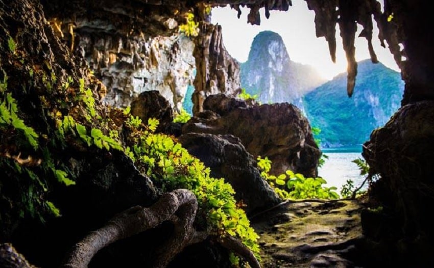
The third group consists of notch caves, which represent a distinctive hallmark of Ha Long Bay’s karst topography. The solvent action of seawater upon limestone, coupled with wave-induced mechanical erosion, carves out deep notches at the base of vertical cliffs. Under favorable conditions, limestone dissolution allows these cliffs to be progressively undercut and widened into caverns. A salient characteristic of notch caves is their perfectly flat, horizontal ceilings cutting cleanly across the limestone strata. Some notch caves were not formed at the present sea level, but rather at paleo-sea levels associated with fluctuations during the Holocene transgression, or even dating back to the Pleistocene epoch. A few have preserved the development of terrestrial karst foot caves or remnants of ancient subterranean caverns. One of the most extraordinary features of Ha Long Bay is the Ba Hầm Lake complex—comprising hidden lagoons and connecting subterranean tunnels (notch caves) on Đầu Bê Island. From the island’s sheer cliff face, a notch cave standing 10 meters above the water leads into a nearly pitch-black winding passage extending about 150 meters into Lagoon 1. Luon Cave, located on Bồ Hòn Island, penetrates 50 meters into an enclosed tidal lagoon. It features a colossal stalactite hanging 2 meters down, truncated neatly at the modern tidal level, bearing witness to a complex multi-stage formation history.
The karst landscape of Ha Long Bay holds international significance and foundational importance for geomorphological science. Fenglin karst, the predominant type across most of Ha Long Bay, represents the most advanced stage of limestone landscape evolution. When making broad international comparisons of karst landscapes based on height, steepness, and density of limestone peaks, Ha Long Bay arguably ranks second worldwide, surpassed only by Yangshou, China. However, Ha Long Bay has also undergone marine submergence, making the geomorphology of its limestone and mainland terrain uniquely shaped, at least in part, by marine erosion. This marine transgression distinguishes Ha Long Bay, rendering it peerless across the globe. While other submerged karst regions exist, none approach the grand scale of Ha Long Bay.
4. Mineral Resources and Other Values
The mineral resource value of Ha Long Bay cannot be overlooked, although resource extraction requires careful consideration in relation to conservation and sustainable development. The Ha Long region harbors colossal limestone reserves amounting to hundreds of millions of tons, with a calcium carbonate purity ranging from 96% to 100%. Preservation efforts must therefore encompass the safeguarding of this massive carbonate reserve. The limestone formation also contains strata of dense black silica, highly valued in artistic materials. Meanwhile, the Hon Gai coal deposits consist of premium-grade anthracite, boasting calorific values between 7,000 and 8,400 kcal/kg, an ash content of 1.2% to 1.5%, and a sulfur content ranging from 0.2% to 1.2%.
Destinations Where Travelers Can Experience the Geological and Geomorphological Values of Ha Long Bay
| Routes | Pricing | Sightseeing Spots |
|---|---|---|
| Route 1 | 310,000 VND/pax | Thien Cung Cave – Dau Go Cave – Chó Đá (Stone Dog) Islet – Ba Hang Cave – Đỉnh Hương (Incense Burner) Islet – Trống Mái (Fighting Cocks) Islet |
| Route 2 | 310,000 VND/pax | Soi Sim Beach – Titop Island – Sung Sot (Surprise) Cave – Tùng Sâu Lagoon – Me Cung Cave – Bồ Nâu Cave – Luon Cave – Trống Cave – Trinh Nu Cave – Động Tiên Lake |
| Route 3 | 260,000 VND/pax | Cửa Vạn Floating Cultural Center – Tiên Ông Cave – Ba Hầm Lake – Bà Men Temple – Áng Dù – Bamboo Forest |
| Route 4 | 260,000 VND/pax | Cỏ Cave (Thiên Cảnh Sơn) – Thầy Cave – Cạp La Cave – Vông Viêng – Tùng Áng Eco-Area – Cống Đó Island – Hòn Xếp Park |
| Route 5 | 310,000 VND/pax | Thien Cung Cave – Dau Go Cave – Chó Đá Islet – Ba Hang – Đỉnh Hương Islet – Trống Mái Islet – Gia Luận Pier (Cat Ba – Hai Phong) |
| Route 6 | 150,000 VND/pax/trip | Chân Voi (Elephant Foot) Islet – Ba Cửa Lagoon – Tùng Lâm Island – Cặp Bài Islet (terminal point of the journey adjacent to Gia Luận, Lan Ha Bay – Hai Phong) |
| Route 7 | 600,000 VND/pax | Ha Long Bay sightseeing across Routes 1-2-3-4 (exclusively applicable for overnight discovery cruises) |
| Route 8 | 70,000 VND/pax/trip | Tuan Chau International Passenger Port – Ha Long International Cruise Port – Nam Cầu Trắng Port |
This concludes all the essential information regarding the geological and geomorphological values of Ha Long Bay. We hope this article has provided you with valuable insights. If you wish to charter a cruise tour to explore Ha Long Bay and experience these extraordinary heritage wonders firsthand, please contact us for further details.