Nestled along the northeastern coast of Vietnam, Ha Long Bay encompasses a vast expanse of approximately 1,500 square kilometers, featuring nearly 2,000 limestone islands of varying sizes that create a unique and diverse geological system. The formation of these majestic limestone karsts is the result of millions of years of geological evolution, culminating in a breathtaking landscape of immense scientific value. In this article, Halong & Lan Ha Bay Cruise Tours invites you to gain a deeper insight into the structure and formation of the limestone islands in Ha Long Bay.
See more: Discover the Cave System in Ha Long Bay
The Limestone Composition of Ha Long Bay
Ha Long Bay is a region of pure limestone eroded into a mature karst landscape characterized by Fengcong and Fenglin landforms. This process occurs through the subaerial erosion of limestone, subsequently modified by marine transgression in its later stages. Hundreds of rock islands that shape the most magnificent and renowned scenery within the bay are isolated towers set within a classic fenglin karst landscape, where intervening plains are submerged beneath the sea (Figure 1).
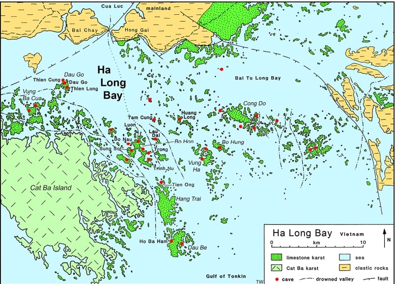
Figure 1: A simplified map of Ha Long Bay, illustrating major islands, prominent geology, and the names of several major caves.
Most of these towers reach heights between 50 and 100 meters, with height-to-width ratios of up to approximately 6. Numerous towers feature vertical walls on all or most sides; they continue to evolve through rockfalls and major fracturing. In 1997, a massive slab of rock detached from a small island north of Cat Ba to expose a fresh vertical face; the fractured surface reveals vertical joints, part of which opened up to form a cave subsequently filled with large stalactites. This fallen block, with a volume of approximately 500 m³, now rests in the sea, undergoing gradual erosion via dissolution and wave action.
Many towers preserve ancient cave remnants within their interiors, while numerous others feature sea notches at their bases as relics of erosion at various levels (Figure 2). Clusters of limestone hills form the larger islands in Ha Long Bay and serve as quintessential examples of Fengcong karst. Summits typically stand at elevations of around 100 meters above sea level, with the highest peaks exceeding 200 meters. Their shapes are predominantly steep cones; except along their marine margins, vertical cliffs are minor components, as they remain uncut where internal linear joints do not intersect the base level. These conical hills also contain remnants of ancient cave passages. Some Fengcong hills exhibit distinct ridges or crests formed along inclined bedding planes within the limestone; aside from these locations, geological structure exerts minimal influence on the limestone hill cross-sections.
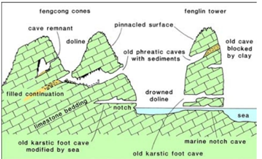
Figure 2. Schematic diagram illustrating the main types of caves in the limestone mountainous region of Ha Long Bay.
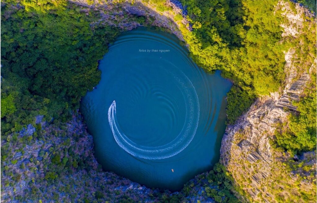
A distinctive feature of Ha Long Bay is the abundance of tranquil lagoons nestled within the limestone islands. Dau Be Island, situated at the mouth of the bay, contains six enclosed lagoons, including the renowned Ba Ham Lake. All lagoons on this island reside within enclosed sinkholes amidst Fengcong karst, locally referred to as “hong” in other parts of Southeast Asia (Figure 3). Their bathymetric profiles remain largely unsurveyed; most appear deep, though some feature shallow flat floors just beneath the water’s surface, and nearly all display marine solution notches carved into their surrounding walls. These lagoons are tidal, as seawater flows freely through the porous limestone—at certain locations via sea-level caves accessible by boat, and at others through inaccessible networks of fissures. A freshwater lake is also documented on the eastern side of Cong Do Island (Figure 6); it likely persists atop a detrital sediment floor, although its detailed geomorphology remains largely unstudied.
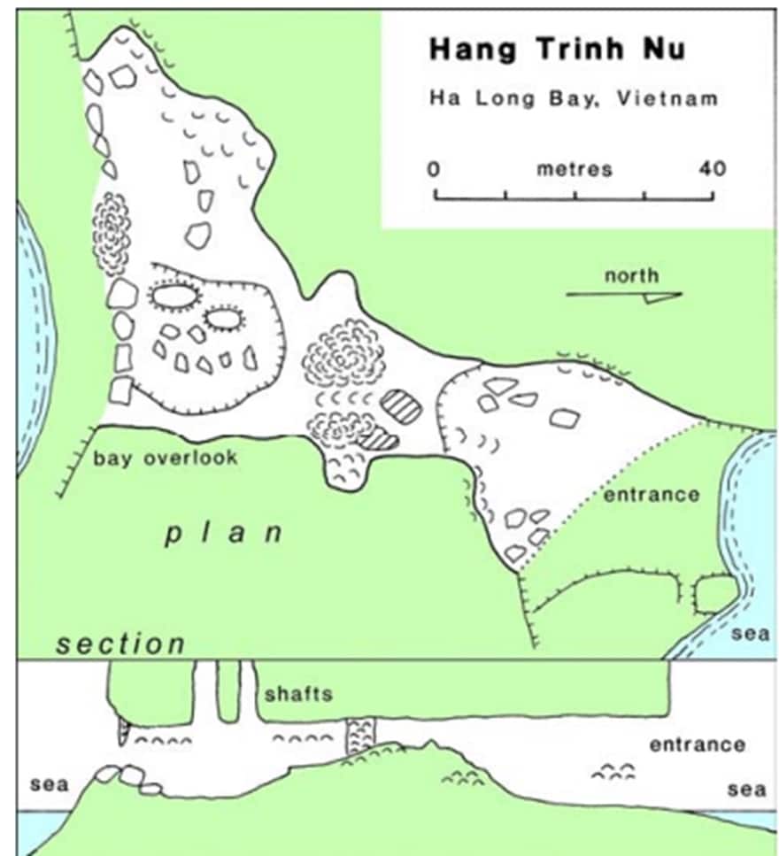
Figure 3: Plan and cross-section of Virgin Cave (Hang Trinh Nu) on Bo Hon Island.
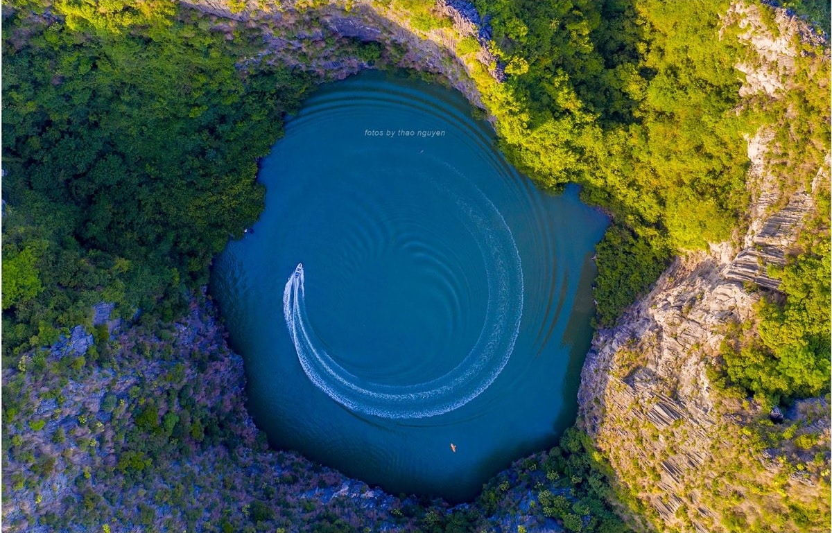
Figure 4. Dolphin Lagoon within the interior of Cong Do Island (Photo: Thao Nguyen)
Many of the shallow marine areas interspersed between the limestone islands appear to be drowned karst plains; the majority of the bay features depths of less than 10 meters. Detrital sediments blanket much of the seafloor, predominantly of marine origin, though remnants of subaerial sediments from ancestral karst plains may persist within buried depressions. Submerged plains along the inner margins of the bay mark where drainage from the Red River and mainland once flowed into the limestone terrain. The Fengcong limestone massifs that currently form the larger islands likely originated from areas of slightly higher baseline topography or fewer surface drainage lines upon the original landscape from which modern karst evolved. All limestone surfaces across the Ha Long Bay archipelago are heavily weathered by dissolution. Peaks, ridges, and residual rock blades exhibit razor-sharp rillenkarren surfaces, creating a rugged and highly impassable terrain. Jagged fissures continue to deepen, devoid of continuous soil mantles or sub-rundkarren soil horizons. Organic soils primarily accumulate within isolated limestone crevices, where they provide a rooting medium for pervasive scrub vegetation. All limestone surfaces display a characteristic dark hue due to blue-green algae inhabiting the rock’s outer rind, which facilitates bioerosion and pitting.
Marine Erosion of Limestone
The marine transgression into the Ha Long Bay karst region introduced a transformative agent that undercuts the limestone islands. The most prominent feature is the principal sea notch carved into virtually all rocky shores. Its deepest indentation typically stands nearly 3 meters high, spanning the normal intertidal range. This is a complex feature, frequently featuring a bench at mid-height and a minor upper undercut extending an additional meter higher; the latter likely reflects storm-wave action and extreme spring tides. Higher paleo-notches mark periods of elevated ancient sea levels and remain inactive today. Features below the low-tide mark have not been observed, and there is no evidence of widespread wave-cut platforms. Across the bay, notch dimensions remain consistent regardless of exposure to high-energy open-sea swells, indicating that these incisions are primarily driven by limestone dissolution. Seawater is generally saturated with calcium carbonate, meaning limestone dissolution relies heavily on the aggressive microenvironment generated by algae within the rock’s surface layers. The dark, algae-infused rinds ubiquitous on subaerial limestone extend down the cliffs into the tidal zone, while marine algal forms undoubtedly play an equally vital yet unrecorded role. Limestone dissolution is further accelerated at sea level by the mixing of marine and fresh waters within the archipelago’s fracture systems. While notches are common to coastal limestone cliffs worldwide, those in Ha Long Bay are exceptionally well-developed, frequently extending inward into impressive arches and sea caves. Under-cutting via these marine notches represents the primary mechanism driving the erosion and retreat of limestone cliff faces. Marine erosion not only accentuates the profiles of the limestone islands but also maintains the steep flanks of the Fenglin towers, thereby preserving the breathtaking majesty of the karst landscape (Figure 5).

Figure 7: A small limestone islet in Ha Long Bay; a residual remnant of a fenglin tower undercut by a marine notch, with a recently collapsed cliff section now resting on a submerged rock platform.
Numerous islands within the bay feature narrow peninsulas formed by towering limestone ridges flanked by vertical cliffs; these sequestered bays are vastly disproportionate to the slender land fragments dividing them, as seen at the northern tip of Dau Be Island. The connecting ridges between peak chains originate in Fengcong karst regions where favorable linear drainage patterns exist. Under normal subaerial weathering, these ridges degrade into lower pillars, ultimately leaving isolated karst pinnacles. The extraordinarily narrow limestone septa of Ha Long Bay are atypical of subaerial Fengcong karst; rather, they are the consequence of accelerated lateral expansion of interior depressions driven by marine erosion. Their presence highlights the crucial role marine processes played in the geomorphological evolution of Ha Long Bay.
Cruise Routes and Pricing for Ha Long Bay’s Iconic Islands and Karst Mountains
To fully appreciate the splendor of Ha Long Bay’s limestone islands and karst peaks, travelers are required to purchase sightseeing tickets along designated official routes. From there, you may select your preferred vessel type (day cruise or overnight luxury cruise) and tailor an itinerary to match your personal travel desires.
For travelers wishing to explore the limestone mountains and check ticket prices or excursion vessels, please visit: #
Introduction to Famous Islands and Limestone Mountains Across the Routes:
-
Fighting Cocks Islet (Hon Trong Mai) (Route 1, Route 5): The iconic symbol of Ha Long Bay, consisting of two limestone monoliths shaped like a pair of roosters locking in combat—an immortal image featured prominently on Vietnam’s tourism publications.
-
Incense Burner Islet (Hon Dinh Huong) (Route 1, Route 5): An island resembling a traditional incense urn, holding profound cultural significance and proudly featured on the Vietnamese 200,000 VND banknote.
-
Dog Stone Islet: A charming small island naturally sculpted into the silhouette of a seated canine.
-
Titop Island (Route 2): Famed for its sweeping crescent-shaped beach of pristine white sand, offering a rewarding trek to its summit for panoramic, bird’s-eye vistas of Ha Long Bay. A quintessential “must-visit” destination.
-
Soi Sim Beach (Route 2): Soi Sim Island boasts an untouched beach, crystal-clear turquoise waters, and a rich, diverse ecosystem. Perfect for travelers seeking natural serenity and quiet beauty.